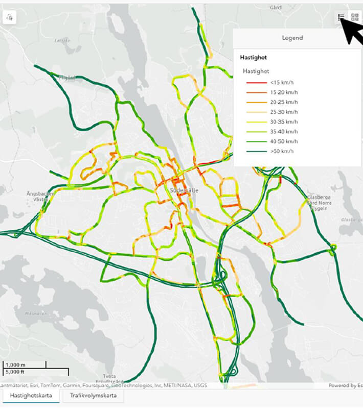
Myriorama
A unified mobility model that reveals how cities truly move
Traffic Twin gives cities and regions a complete, system‑wide view of mobilityby integrating walking, cycling, public transport, and car travel into a single coherent digital model.
Built on a statistically robust synthetic population, it transforms fragmented traffic data into clear, decision‑ready insights without compromising privacy.

Fragmented data leads to fragmented decisions.
Today, traffic planning is often done in silos: each mode—walk, bike, public transport, car—is analysed separately. That creates a fragmented view and makes prioritisation harder.
At the same time, available traffic data is frequently incomplete, inconsistent, or difficult to interpret—so planners struggle to understand what’s really happening today.
Analyses become slow and expensive, relying on multiple external consultants and different models—where every change request adds time and cost. And when it’s difficult to simulate future changes, decisions are made with uncertainty—leading to misinvestments.
The result is planning that risks being driven by guesswork rather than best available knowledge: streets get over-dimensioned, while walking and cycling are underestimated—and the pace of planning slows down.
.jpg)
Why Traffic Twin makes a difference
Text
- One model for the entire mobility system
Walking, cycling, public transport and car travel in a unified structure. - Scenario testing in minutes, not months
Compare baseline and future scenarios side‑by‑side to understand system‑wide effects. - Strategic confidence for planners and decision‑makers
Clear, visual insights that strengthen internal collaboration and political dialogue. - A platform that evolves with your needs
Start with a robust base model and refine it with additional data sources over time. - Built on proven, national‑scale data foundations
Register‑based population modelling, validated traffic flows and established methodologies.


.png)


