Flowmapper
Transforming public transport planning with data-driven insights.
Flowmapper empowers municipalities, transit authorities, and operators to make informed decisions using billions of real-time data points. By visualizing and analyzing public transport performance, it enhances punctuality, reduces travel times, and fosters more efficient and sustainable transit networks.
Why public transport needs a rethink — and how Flowmapper is changing the game.
Public transport systems are the backbone of sustainable urban mobility, yet many still rely on outdated planning models. Decisions are often based on sparse data, assumptions, or legacy infrastructure assessments. The result is a system plagued by inefficiencies: delayed buses, congested corridors, underperforming routes, and ultimately, declining passenger satisfaction.
These challenges aren’t just operational—they’re economic. They can cost Swedish society over 1 billion SEK per year, factoring in increased operating expenses, missed economic activity, and lost fare revenue.
Furthermore, traditional transport planning tools often lack the spatial resolution and historical depth needed to pinpoint systemic issues. For example, urban bottlenecks might only delay traffic for a few minutes daily—but at scale, this erodes reliability across an entire network. Transit planners are left making reactive changes instead of proactive, evidence-based improvements.
Flowmapper was created to address these gaps. The modern city needs a modern tool—one that sees not just where vehicles should go, but where they actually struggle, and why.


100
billion data points analyzed
509
SEK/year in potential cost savings in Sweden
800
SEK/year in potential increased revenues in Sweden
25,219
transit stops analyzed across Sweden
The new standard for smarter, data-driven transit planning.
Flowmapper is a next-generation analytics platform that turns massive volumes of transit data into actionable intelligence. Designed for municipalities, regional authorities, and transport operators, it enables users to make faster, smarter, and more sustainable decisions.
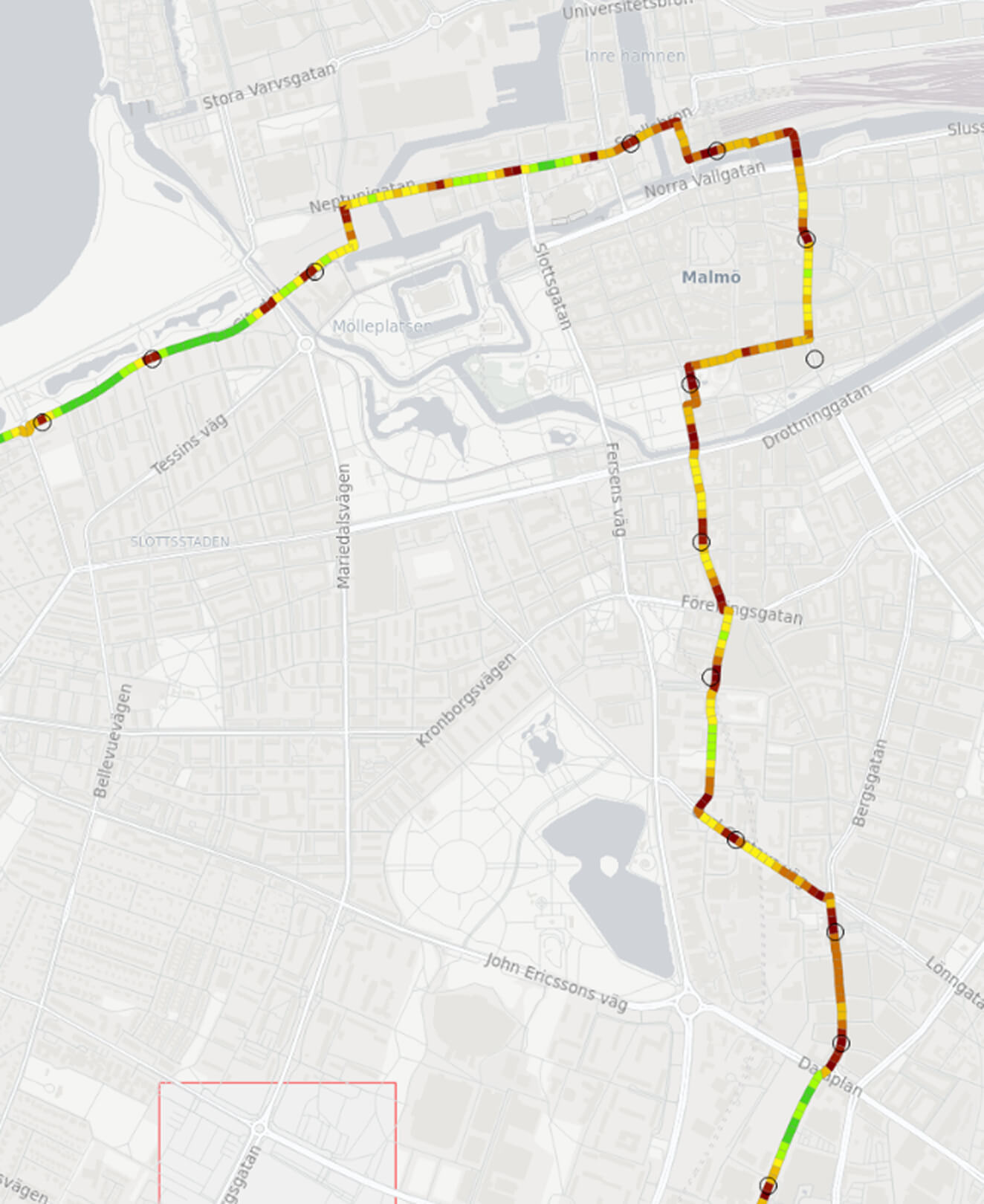
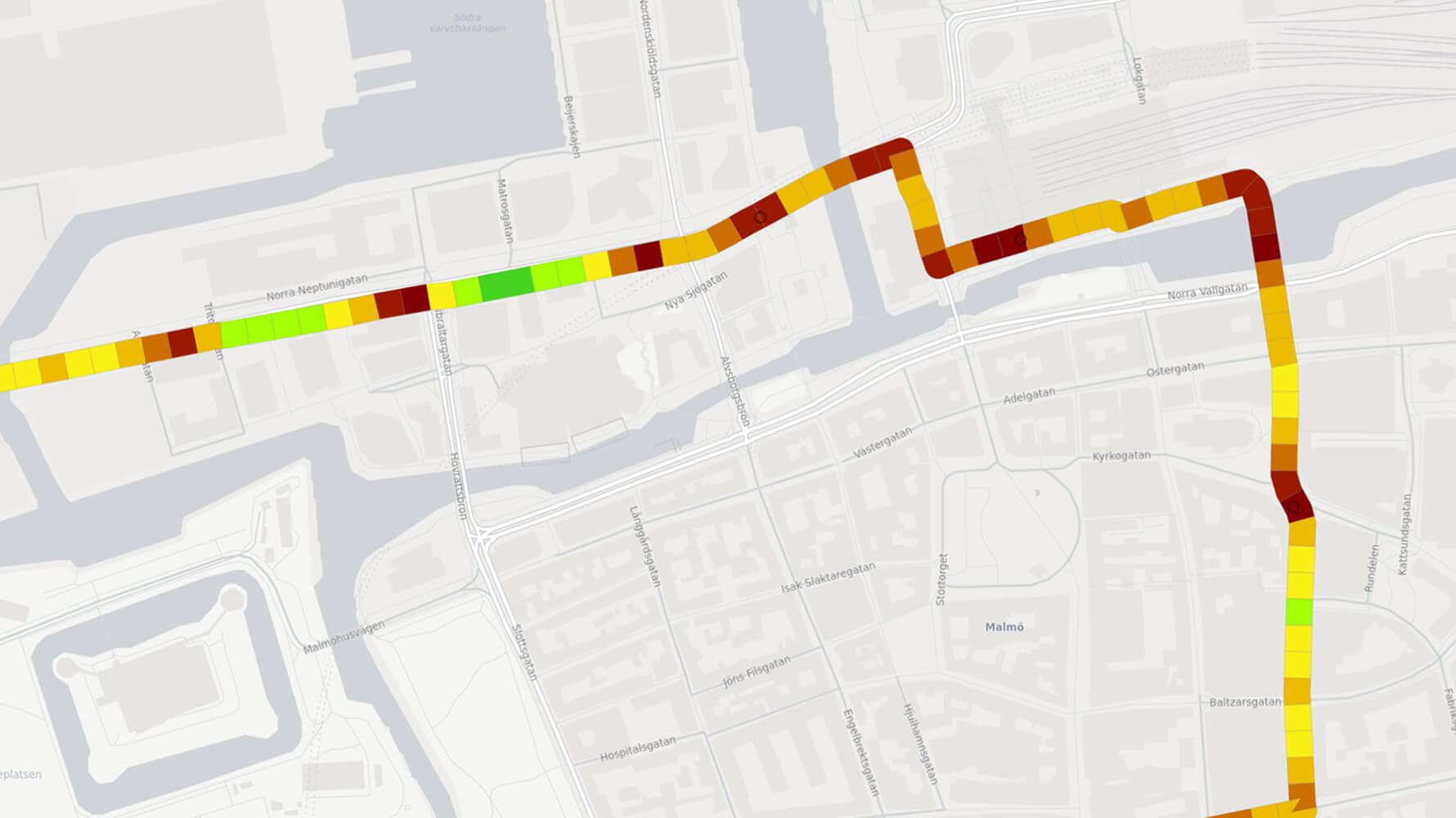
At its core, Flowmapper processes billions of GPS data points to visualize vehicle movement across the entire public transport system—down to 25-meter resolution. It reveals detailed patterns of delay, inefficiency, and service inconsistency that traditional models miss.
By using Flowmapper, cities like Uppsala have already uncovered previously invisible issues, allowing for smarter redesigns and improved timetables. Flowmapper isn’t just a digital tool—it’s a new standard for evidence-based transit planning.
Flowmapper's powerful capabilities
- Bottleneck Detection: Flowmapper automatically identifies congestion points and accessibility issues using spatial-temporal analysis. Planners can filter by time of day, vehicle type, or specific routes to drill into root causes.
- Comparative Line Analysis: Benchmark multiple lines using KPIs like average speed, stop spacing, dwell time, and punctuality. This empowers decision-makers to prioritize investments or restructure routes for better performance.
- Timetable AI: By analyzing actual travel times over weeks and months, Flowmapper’s AI generates realistic, adaptive timetables. This drastically reduces manual work and ensures timetables reflect on-the-ground conditions—not assumptions.
- Impact Tracking: After interventions, Flowmapper continues to collect and visualize data—making it easy to measure improvements over time and validate ROI.
- Intuitive Interface: Developed with and for transit professionals, the platform combines technical power with a user-friendly dashboard that makes data actionable at both strategic and operational levels.
From insight to action – in real cities
Cities like Uppsala have already used Flowmapper to uncover previously invisible issues in public transport.
The result? Smarter redesigns and improved timetables. Flowmapper is more than just a digital tool—it’s a new standard for evidence-based transit planning.


Stay updated
Join our newsletter for updates, insights, and the latest news from Flowmapper.