Traffic Twin
A unified traffic model that shows how cities actually move.
Traffic Twin helps cities and regions see the full mobility system in one coherent picture—walking, cycling, public transport, and car travel—without privacy trade-offs. It’s built on an individual-based, statistically correct population model that turns fragmented traffic data into decision-ready insight.

Fragmented data leads to fragmented decisions.
Today, traffic planning is often done in silos: each mode—walk, bike, public transport, car—is analysed separately. That creates a fragmented view and makes prioritisation harder.
At the same time, available traffic data is frequently incomplete, inconsistent, or difficult to interpret—so planners struggle to understand what’s really happening today.
Analyses become slow and expensive, relying on multiple external consultants and different models—where every change request adds time and cost. And when it’s difficult to simulate future changes, decisions are made with uncertainty—leading to misinvestments.
The result is planning that risks being driven by guesswork rather than best available knowledge: streets get over-dimensioned, while walking and cycling are underestimated—and the pace of planning slows down.

Turning complex traffic data into a living traffic twin.
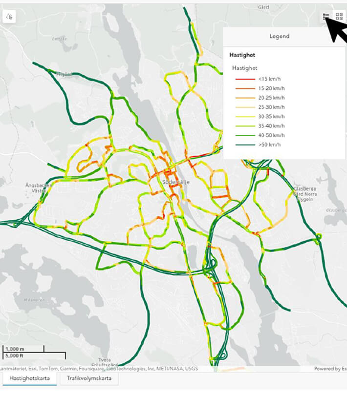
Traffic Twin creates a living, digital mirror of how people actually move through a city or region—across walking, cycling, public transport, and car travel—within a single, coherent model.
At its core is an individual-based, statistically correct synthetic population. Instead of tracking real individuals, Traffic Twin represents realistic people, activities, and trips at population level—making it possible to understand mobility patterns without privacy or data integrity concerns.
The model brings together multiple data sources—such as mobile network data, traffic measurements, and travel surveys—into one consistent foundation. This resolves the common problem of fragmented and incompatible datasets, replacing them with a shared view of the entire mobility system.
Because every trip is part of a connected whole, Traffic Twin makes it possible to explore how changes in one part of the system affect all others. Planners can test scenarios by adjusting population characteristics, land use, or travel conditions—and immediately see how those changes shift travel behaviour across all modes.
The result is not just analysis, but understanding: a faster, more transparent way to explore today’s reality and evaluate tomorrow’s decisions—before they are built.

.png)
Heading
Text
Heading
Text
Heading
Text
Heading
Text